


Tropical Storm Gabrielle, the Atlantic’s seventh named system of the 2025 hurricane season, is gathering strength and may evolve into a hurricane by the weekend. As it tracks north-northwest over open waters, its projected path carries possible impacts for Bermuda, while much of the U.S. East Coast, Caribbean islands, and Gulf states remain on alert—but are not yet under direct threat. Below is the latest forecast, detailed track maps, regional wind speed projections, and guidance for Bermuda and nearby islands.
Formation, Current Status & Movement
- Origin & Location: Gabrielle officially formed on Wednesday, September 17, roughly 990 miles east of the Northern Leeward Islands.
- Current Strength: The storm is sustaining winds of about 50 mph (80 kph), moving west-northwest at approximately 12-15 mph (19-24 kph).
- Atmospheric Conditions: The system is contending with dry air intrusion and moderate westerly wind shear, which has been limiting deeper organization. Convection is improving near the center, though the structure remains somewhat asymmetric.
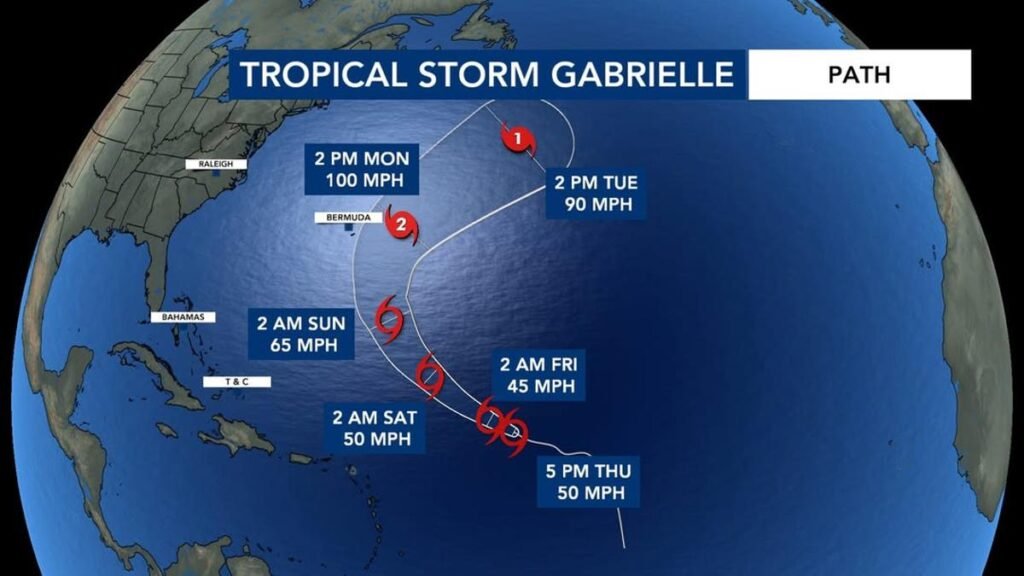
Forecast Track & Timeline (Maps & Models)
Forecast maps and “spaghetti models” (multiple international models overlaying possible tracks) show consistent guidance:
- Gabrielle is expected to move west-northwest, then gradually turn more north-northwest and eventually recurve toward the northeast as it approaches the subtropical Atlantic.
- Over the weekend, the storm is forecast to strengthen, then begin curving around the western edge of a mid-tropospheric high-pressure ridge, with a trough over the southeastern U.S. aiding the northward turn.
- According to several model consensus plots, Gabrielle will likely pass to the east of Bermuda around Sunday night into Monday, before accelerating northeast into open waters. A close pass is possible, but direct landfall is considered unlikely in the current track guidance.
Wind Speed Projections by Region & Forecast Strength
| Time Period | Location / Region | Forecast Wind Speeds (Sustained) |
|---|---|---|
| Now – Next 24-48 hours | Open Atlantic (E of Leeward Islands) | ~50 mph tropical storm strength; gusts higher in heavy convective bands. |
| 48-72 hours (Saturday-Sunday) | Central Atlantic, warmer waters north of current position | Gradual intensification; winds may increase to 60-70 mph as Gabrielle becomes a hurricane. |
| Weekend into Monday | Near Bermuda waters & storm’s northeastern arc | Central Atlantic, warmer waters north of the current position |
| Post-Monday | Beyond Bermuda turn toward open Atlantic | Gradual weakening expected as storm enters cooler waters or interacts with mid-latitude atmospheric flow; sustained winds declining toward 75-90 mph, then further. |
What Bermuda & Nearby Islands Should Prepare For
Even though Gabrielle is not expected to make direct landfall in Bermuda under most model forecasts, there are several potential hazards and impacts to monitor:
- Tropical-Storm-Force Winds
There remains a roughly 20-25% chance that Bermuda could experience tropical-storm‐force winds (about 39-73 mph) depending on the exact storm track and whether the northern edge of Gabrielle brushes the island. - High Surf and Dangerous Rip Currents
Swells generated by Gabrielle are already reaching Bermuda. Through the weekend, surf is expected to grow more intense, with life-threatening conditions possible along reefs, rocky shorelines, and beaches. Swells and surf may be elevated even before wind impacts arrive. - Rainbands & Localized Heavy Rain
Outer bands of Gabrielle could bring bursts of heavy rain, gusty thunderstorms, and possible flash flooding, especially in higher elevations or areas with poor drainage. These impacts are most likely if Gabrielle tracks closer than currently projected. - Timing of Impacts
Bermuda should watch for possible impacts Sunday night into Monday, when the storm is forecast to be near its strongest and closest to the island. Before that, conditions offshore will deteriorate (swells, rough sea state) over the weekend.
Other Areas / U.S. East Coast & Caribbean Watch
- U.S. East Coast: Current guidance puts Gabrielle too far east for direct landfall in the U.S. However, coastal areas should stay alert for elevated surf, dangerous rip currents, and possible marine impacts if the storm strengthens as projected.
- Caribbean / Leeward Islands: The models show Gabrielle remaining north of the northern Leeward Islands. The islands may see some swell, occasional gusts, or rainfall if spiral bands extend far, but major impacts are not expected.
Key Uncertainties & What to Monitor
- Wind Shear & Dry Air: These hostile factors are currently suppressing Gabrielle’s organization. If shear lapses and moisture increases, intensification could be faster than currently modeled.
- Sea Surface Temperatures: Warm Atlantic waters will fuel strengthening, particularly as the storm moves northward; cooler waters and less favorable conditions will likely weaken it later.
- Model Divergence: While consensus is relatively strong for a near-miss of Bermuda, ensemble models (HCCA, GFS, ECMWF, etc.) show spread in track positions, especially after 3-4 days. Small changes in the path could shift land-impact risk.
Preparedness Advice for Bermuda & Mariners
- Stay updated with the National Hurricane Center (NHC) forecasts and any local Bermuda meteorological advisories.
- Coastal communities should prepare for dangerous surf and consider delaying non-essential marine operations.
- Ensure storm-ready kits are prepared: water, non-perishable food, flashlights, and secure loose outdoor items.
- Travelers should keep an eye on flight schedules, ferry services, and lodging advisories in Bermuda.
- Residents and visitors should monitor local flood and sea surge guidance, especially in coastal and low-lying areas.
Tropical Storm Gabrielle is slowly but steadily gaining strength over the central Atlantic. While wind shear and dry air have hindered organization, conditions are expected to become more favorable this weekend, likely allowing Gabrielle to reach hurricane status by Sunday. The storm is projected to pass well east of the Caribbean islands but may come close to Bermuda around Sunday night into Monday, bringing potential for tropical-storm-force winds, rough surf, and hazardous marine conditions. Fortunately, most forecasts show a recurvature that will carry the storm away from major land impacts afterwards.
For Bermuda, the next 48 hours will be critical in refining the track and intensity forecasts. Stay alert, plan accordingly, and avoid complacency—even a near-miss can carry dangerous effects.
Forecasts may change; keep checking official updates from NHC and Bermuda’s weather services as Gabrielle progresses.